

Key Takeaways
Climate Data Collection
Climate data collection refers to the systematic gathering of measurements from Earth's atmosphere, oceans, land surface, and ice over long periods of time. Scientists use a wide array of instruments - from orbiting satellites to deep-sea buoys to ancient ice cores - to build the detailed picture of how Earth's climate is changing. These datasets, often spanning decades or centuries, form the evidentiary foundation of climate science.
Climate datasets must meet strict quality-control standards, including homogeneity testing to detect and correct for changes in instrument type, station location, or observation practice over time.
Why Collecting Climate Data Is Complicated
Understanding Earth's climate requires more than a thermometer and patience. Climate - as distinct from day-to-day weather - is defined by long-term patterns across the entire planet. That means scientists need measurements that are global in scope, consistent over decades, and precise enough to detect gradual changes. To understand the difference between these two concepts more deeply, see why climate and weather are so easy to confuse.
No single instrument can do the job. A ground station in Nebraska tells you nothing about the Pacific Ocean. A satellite orbiting at 400 miles cannot drill into glacial ice. That is why modern climate science depends on an integrated, multi-source observing system - one that took generations of international cooperation to build.
~4,000
Argo floats monitoring ocean temperature globally
As of recent years, the Argo program operates roughly 4,000 autonomous floats distributed across the world's oceans.
800,000 years
Length of Antarctic ice core climate record
The EPICA Dome C ice core from Antarctica provides a continuous climate record stretching back approximately 800,000 years.
>90%
Share of excess heat absorbed by Earth's oceans
According to multiple studies published in peer-reviewed journals, the world's oceans have absorbed more than 90 percent of the extra energy trapped by greenhouse gases since the mid-20th century.
Satellites: The View From Above
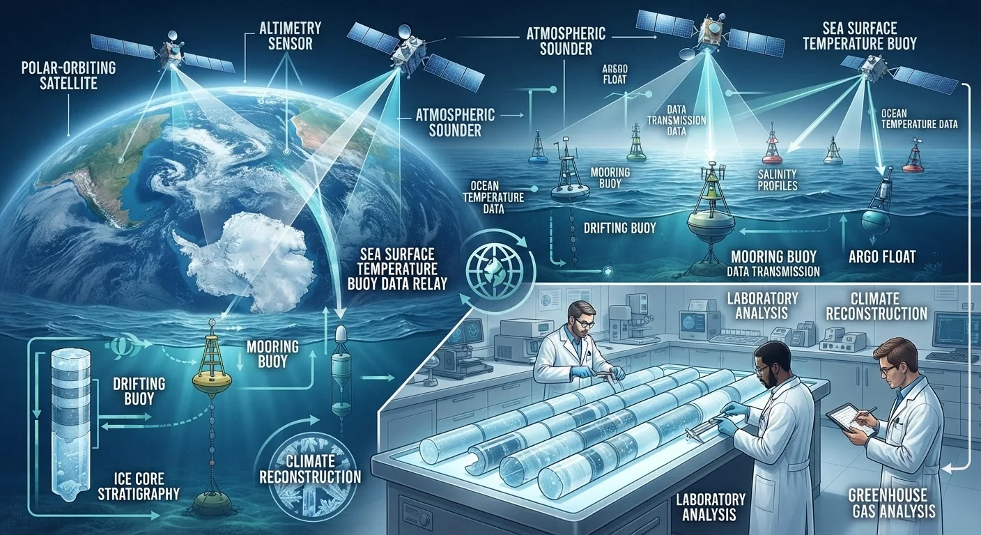
Orbiting satellites are the workhorses of modern climate observation. NASA's Terra and Aqua satellites, along with NOAA's operational weather satellites, continuously measure variables including sea surface temperature, Arctic and Antarctic sea ice extent, cloud cover, atmospheric greenhouse gas concentrations, and vegetation health.
A key satellite tool is AVHRR - a sensor that has tracked sea surface temperatures globally since 1981. NASA's GRACE and GRACE-FO missions use tiny variations in Earth's gravitational field to measure changes in ice sheet and groundwater mass, providing a wholly independent confirmation of ice loss observed by other means.
Satellite records require careful calibration because instruments degrade in orbit and individual satellites are periodically replaced. Scientists overlap old and new satellite datasets to ensure continuity, and cross-validate against surface measurements.
Ocean Buoys and Argo Floats: Listening to the Seas
The ocean absorbs more than 90 percent of the excess heat trapped by greenhouse gases, making ocean temperature monitoring essential. Surface mooring buoys - thousands of them anchored across every major ocean basin - measure sea surface temperature, salinity, wave height, wind speed, and atmospheric pressure in near real-time.
Deployed since 2000, the Argo program operates roughly 4,000 autonomous floats that drift with ocean currents, diving to depths of up to 2,000 meters and surfacing every ten days to transmit temperature and salinity profiles via satellite. Together, Argo floats have transformed understanding of how heat moves through the ocean's interior - data that was simply unavailable to earlier generations of climate scientists.
Ship-based measurements and underwater gliders complement buoys for deeper ocean profiling and specific research campaigns. For more on how warming alters these systems, see how climate change is reshaping the water cycle.
Ice Cores: Earth's Deep Climate Archive
When snow falls on Antarctica or Greenland, it traps tiny air bubbles, dust particles, and chemical signatures from the atmosphere of that moment. As layers accumulate and compress into ice over thousands of years, they form a detailed, datable archive of past climate. Scientists drill cores - cylinders of ice sometimes stretching over two miles deep - and analyze them layer by layer.
The EPICA Dome C ice core from Antarctica has provided a continuous climate record extending back approximately 800,000 years, covering eight glacial-interglacial cycles. Measurements of isotopes like deuterium reflect past temperatures, while trapped air bubbles reveal ancient concentrations of CO₂ and methane with remarkable precision.
This is why ice cores are among the most powerful climate proxies available: they directly measure past greenhouse gas levels, not just infer them. If you are newer to these underlying concepts, this beginner's introduction to climate science covers the foundational ideas clearly.
Ground Stations, Tree Rings, and Other Sources
Surface weather stations - coordinated through the World Meteorological Organization's Global Climate Observing System - provide the longest direct instrumental record. Thousands of stations across every continent record temperature, precipitation, humidity, and pressure daily, some with continuous records dating to the 1800s.
Beyond instruments, proxy archives extend the record far into the pre-industrial past. Tree rings encode annual growth conditions: wide rings suggest warm, wet years; narrow rings indicate stress. Coral skeletons record ocean temperature through isotope ratios. Lake sediment cores capture pollen, dust, and algae that shift with regional climate. These proxies are independently calibrated against the instrumental record before being used to extend it backward.
Understanding how all these data streams fit together helps explain how scientists distinguish natural climate variability from human-caused warming. Multiple independent lines of evidence pointing to the same conclusion are at the core of scientific confidence in climate findings - a point worth keeping in mind when evaluating common misinformation patterns in climate science.